


PRECINCT RIVERSIDE-Q, Montgomery County, Ohio
About
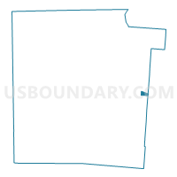
Outline

Summary
| Unique Area Identifier | 650297 |
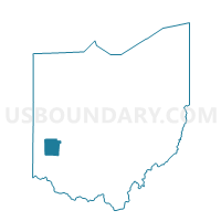
| Name | PRECINCT RIVERSIDE-Q |
| County | Montgomery County |
| State | Ohio |
| Area (square miles) | 0.46 |
| Land Area (square miles) | 0.46 |
| Water Area (square miles) | 0.00 |
| % of Land Area | 100.00 |
| % of Water Area | 0.00 |
| Latitude of the Internal Point | 39.74014350 |
| Longtitude of the Internal Point | -84.11276220 |
Maps

Graphs
Select a template below for downloading or customizing gragh for PRECINCT RIVERSIDE-Q, Montgomery County, Ohio


Neighbors
Neighoring Voting District (by Name) Neighboring Voting District on the Map
- PRECINCT BEAVERCREEK 011, Greene County, OH
- PRECINCT DAYTON 20-C, Montgomery County, OH
- PRECINCT DAYTON 20-G, Montgomery County, OH
- PRECINCT KETTERING 1-E, Montgomery County, OH
- PRECINCT RIVERSIDE-D, Montgomery County, OH
- PRECINCT RIVERSIDE-L, Montgomery County, OH
- PRECINCT RIVERSIDE-R, Montgomery County, OH
Top 10 Neighboring County Subdivision (by Population) Neighboring County Subdivision on the Map
- Dayton city, Montgomery County, OH (141,527)
- Kettering city, Montgomery County, OH (55,696)
- Beavercreek township, Greene County, OH (52,156)
- Riverside city, Montgomery County, OH (25,201)
Top 10 Neighboring Place (by Population) Neighboring Place on the Map
- Dayton city, OH (141,527)
- Kettering city, OH (56,163)
- Beavercreek city, OH (45,193)
- Riverside city, OH (25,201)
Top 10 Neighboring Unified School District (by Population) Neighboring Unified School District on the Map
Top 10 Neighboring State Legislative District Lower Chamber (by Population) Neighboring State Legislative District Lower Chamber on the Map
Top 10 Neighboring State Legislative District Upper Chamber (by Population) Neighboring State Legislative District Upper Chamber on the Map
Top 10 Neighboring 111th Congressional District (by Population) Neighboring 111th Congressional District on the Map
- Congressional District 7, OH (683,371)
- Congressional District 8, OH (663,644)
- Congressional District 3, OH (640,899)
Top 10 Neighboring Census Tract (by Population) Neighboring Census Tract on the Map
- Census Tract 25, Montgomery County, OH (5,063)
- Census Tract 2103, Greene County, OH (3,585)
- Census Tract 909, Montgomery County, OH (3,537)
- Census Tract 213.01, Montgomery County, OH (2,848)
- Census Tract 910, Montgomery County, OH (2,550)
- Census Tract 28, Montgomery County, OH (2,160)